
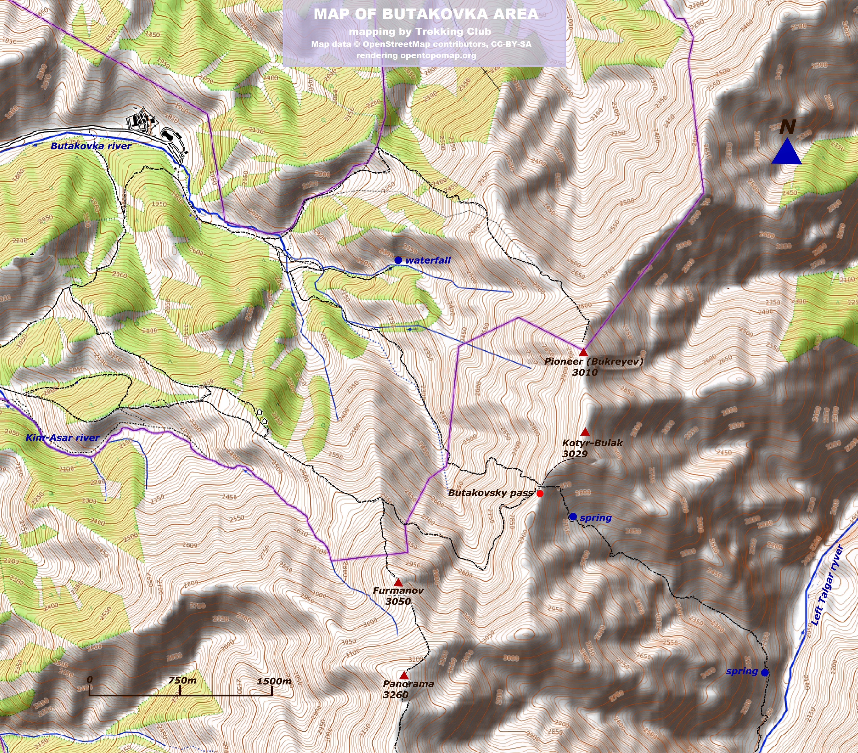
Butakovka is a name of a lateral gorge in Maloalmatinsky ravine, Zailisky Alatau mountains. Being a part of Almaty city, the entrance to the canyon is easily reachable by bus or car so the gorge looks really popular among the citizens. The location provides great opportunities for hiking, rock climbing, mountain biking and camping. When visiting Butakovka, do not miss a chance to climb Kotyrbulak trekking peak (3050m), which seems to be a perfect point to enjoy the North Tien Shan panorama from the bird’s eye view. Another attraction is waterfalls: there are 2 big falls in this area, and one of them is a mecca for Almaty climbers: climbing routes are set on the wall along the water stream.
|
CLIMATE
Temperatures:
- April:
+2°...+12°C daytime;
-5°...+5°C in the night
- July:
+20°...+30°C daytime;
+10°...+20°C in the night
- October:
0°...+10°C daytime;
-8°...+2°C in the night
- January:
-10°...-20°C daytime,
-15°...-25°C in the night
Snow cover:
- April 1-2m
- July --------
- October 0.1-0.2m
- January 0.5-1 m
|
INFRASTRUCTURE
Roads: there are 15km of good asphalt road from Almaty to the end of Butakovka gorge, without significant ascents.
Trails: those marked on the map are comfortable and frequently used.
National Parks: an upper reach of Butakovka River is a territory of the Ili Alatau NP. There is a NP station in the middle of the gorge, entrance fee is required (KZT 450 p/p as it was in 2018).
Petrol stations: there are no petrol stations outside of Almaty in this direction.
Shops and cafes: at the end of asphalt road there are few cafes. No infrastructure in the upper reaches of the gorge.
Water: there are few clean springs along the gorge, with drinking water
Cellular coverage: good cellular connection along the asphalt roads. The connection is unstable in narrow parts of the canyon and along the high ridges
|
ACCOMMODATION
Guest houses
• no guest houses in this area
Camping
• there are many good places (glades) for tent camping along the Butakovka river. Permission for tent camping is not required.
|
|
HOW TO GET FROM ALMATY
Drive to the south by Dostyk avenue, following the gorge up to the fork with a sign “Butakovka” (7.000m before Medeo). Here turn left and follow the asphalt road up, along the river.
|
WHAT TO SEE AND DO
Nature: spruce forests in the foothills of the Zailisky (Trans-Ili) Alatau, waterfalls
Summer activity options:
- day waterfall hiking
- trekking peak climbing (up to 3100m)
- trekking 2-3 days
- rock climbing in a waterfall area (the routes are set with anchors)
- mountain biking
- camping
Winter activity options: ski tour, winter hiking
|
POSSIBLE RISKS
In March and April, due to warming and a large amount of snow on the slopes of the gorge, an avalanche situation may develop
|
Activity options:
Ascent to the Kotyrbulak trekking peak (3050m) via Butakovsky pass
Having reached the end of the asphalt road (here there is a parking), we cross the stream and hike up along the dirt road following the river, upstream. The road leads to a ruined campsite. Here turn right to the path which runs along the main riverbed. The path gradually rises to the right slope and traverses to the headwaters of the gorge, without significant ascents. Crossing the springs, we approach a wide glade, from where the ascent to Butakovskiy pass start (this part takes 1.5-2 hours). A serpentine trail runs up the slope and leads to the crest (steepness of about 35 degrees). The ascent to the pass can take 40-50 minutes. There is a fork on the pass: the way down to the other side leads to the Left Talgar gorge, and the path to the right traverses the slope and leads to Medeo. In order to reach the peak of Kotyrbulak, you need to turn left (south) and follow up the unsteep crest up. There are 20-30 minutes of walking by the crest to the summit. Descent from the top: either following the same way (used for climbing up), or may go further south along the ridge through the peak of Bukreev, to the Pass of Lesnoy. From there, take the path down to the Butakovskoe Gorge.


