 |
 |
Expedition of Trekking Club Team to Khan Tengri. Summer 2006 |
|
|
 |
KHAN TENGRI
(a description of ascent on the classical route from the north)
An expedition by Trekking Club
Summer 2006
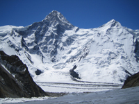
 At 14:45 on July 31, 2006 , we approached the tripod on top of Khan Tengi. We set up radio communication, took a few pictures of manly faces, and glancing over a striking panorama of the surrounding peaks, hurried downward – not knowing yet that it would take us much longer to get down because of rescue operations that had begun below. At 14:45 on July 31, 2006 , we approached the tripod on top of Khan Tengi. We set up radio communication, took a few pictures of manly faces, and glancing over a striking panorama of the surrounding peaks, hurried downward – not knowing yet that it would take us much longer to get down because of rescue operations that had begun below.
There were four of us who to the Mountain – two climbers from Ukraine (Igor Kushnir and Volodya Kravchenko) and two Kazakh guides from Trekking Club (Kirill Belotserkovskiy and Artyom Skopin). We did not take pains on the very first day but rather acclimatized ourselves in a most sparing way, with two overnight stops in Camp 2 instead of one stop in Camp 3. And so, after we got used to the height, on the 13th day of our stay in Severnyi Inylchek, we were ready to ascend.
 Nobody rushed, everyone realized they needed to spare their efforts for the ascent. That is why the whole group was going from camp to camp in a well-coordinated and planned way. Nevertheless, everyone felt tired as early as in Camp 3 on the bridge (5,800), and a decision was made to have a day off there. However, after we woke up and had breakfast, we decided not to waste time and set up the camp on a small landing at 6,200. We could have probably reached 6,400 (Camp 4) on the same day, too, but there were 3 tents already there, and our hangar just wouldn’t fit in. Nobody rushed, everyone realized they needed to spare their efforts for the ascent. That is why the whole group was going from camp to camp in a well-coordinated and planned way. Nevertheless, everyone felt tired as early as in Camp 3 on the bridge (5,800), and a decision was made to have a day off there. However, after we woke up and had breakfast, we decided not to waste time and set up the camp on a small landing at 6,200. We could have probably reached 6,400 (Camp 4) on the same day, too, but there were 3 tents already there, and our hangar just wouldn’t fit in.
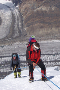
We left the tent for ascent at 8 in the morning. A few minutes later, Volodya refused to go on saying his feet were freezing. Kirill saw  him down, caught up with Igor and me, and the three of us went on. On that day, there were a lot of people on the Mountain, around 15 or 20. Some of them set off from Camp 4 (6,400), while others, from Camp 3 (5,800). We were the last ones, and near the top, they tried to make us turn back due to late evening. But we stood up for our right to ascend and went on. On top, we tied up the logo of Trekking Club to the tripod, took a few pictures and hurried back. We were descending rather quickly, and I thought we would come to the tents by 9 PM. However, at 6,700 we came across a bunch of people on the handrail – a plug. It turned out a girl from Krasnodar felt sick, and she was being dragged down on the rails. So there was nothing to do but wait. We were descending very slowly, with frequent stops. I remember myself sitting on a knapsack sleeping, at about 6.600. We entered the tent only at 12:30 AM. him down, caught up with Igor and me, and the three of us went on. On that day, there were a lot of people on the Mountain, around 15 or 20. Some of them set off from Camp 4 (6,400), while others, from Camp 3 (5,800). We were the last ones, and near the top, they tried to make us turn back due to late evening. But we stood up for our right to ascend and went on. On top, we tied up the logo of Trekking Club to the tripod, took a few pictures and hurried back. We were descending rather quickly, and I thought we would come to the tents by 9 PM. However, at 6,700 we came across a bunch of people on the handrail – a plug. It turned out a girl from Krasnodar felt sick, and she was being dragged down on the rails. So there was nothing to do but wait. We were descending very slowly, with frequent stops. I remember myself sitting on a knapsack sleeping, at about 6.600. We entered the tent only at 12:30 AM.
Descent to the base camp took up the whole of the next day. We reached it at dusk, tired but satisfied. Civilization at last! Light, hot food, and a BATH ! The next day, a helicopter took us to the valley.
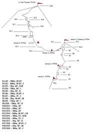
The base camp is almost opposite the beginning of the route, on a lateral moraine of the Severnyi Inylchek Glacier. It is a 40-minute walk across the glacier from the base camp to the beginning of the route. The way to the mountain is usually marked with poles. The route begins with a slope of about 30 degrees steep. Early in the season, there is snow here, and quite heavy avalanches occur, leaving visible traces below. In August, however, the snow melts down to bare the glacier with transverse crevasse. In the upper part (where the rails begin), the slope closes with seracs which must be passed on the left, exiting to the firn ridge. A hundred meters more on the ridge, there is Camp 1 (4,500). Camp 1 has two talus pads – the first one (lower) can accommodate 12-15 tents, and if you go up 100 meters more, you can set up 3 or 4 tents more here on the shoulder. It takes 3 hours to get from the base to Camp 1 at a medium pace.
Camp 2 is on a protruded shoulder at 5,300 m . The pad is very convenient and spacious although oftentimes hit by strong gusts. That is why the tents must be fenced off with snow walls. It takes 6 or 7 hours to Camp 2 at a medium pace, and the way looks like a snow and ice edge with occasional rocks. There are rails all the way through.
The way from Camp 2 to Camp 3 crosses the shoulder of Peak Chapayeva (6,100). The ascent begins on the 35° slope which is about 150 meters long, to a narrow snow knife. Right at the exit to the knife, a string of rails begins and continues to the Chapayeva shoulder. The knife is about 30 meters long, followed by a 30° slope ( 250 m ) exiting to the rocks. Be careful when going along the slope – it may be avalanche-risky in the beginning of the season. The rocks are 70° steep, 40 m , and go out to a talus slope with ice spots, 30-35°, 200 m . Then, rocks begin again at 40-60°, 150 m , which require attention due to freely lying boulders! The final rise to the Chapayeva shoulder on the firn slope is behind the rocks, 150 m . The way to this point from Camp 2 takes up 6 to 7 hours at a medium pace. Descent from the shoulder towards the bridge, where two classical routes to Khan Tengri merge, is not difficult but you must watch out for the hanging massive ledges, 800 m . It is recommended to go in bundles in the broadest part of the bridge.
Technically, the way from Camp 3 to Camp 4 (6,400) is more complicated than all previous ones, and takes up about 4 hours with no luggage. The rails begin at 5,900 from a rise to the rock wall: 50°, 40 m . Then pass the gendarme on the right to exit to a talus corridor and follow it to the next string of rails, 100 m . The rails begin from the end of the corridor and go almost to the top without any breaks. The way mostly follows the rocks, and sometimes goes left or right to evade a steep point. Camp 4 can accommodate three tents if put up close to each other. There are lower pads – 6,100, 6,200 and 6,300, but they are very narrow and have limited space.
The top is usually stormed either from the bridge (5,800) or Camp 4 (6,400). It is recommended to leave Camp 3 earlier, at dawn. It may be quite cool but there will be more time. You can leave Camp 4 at about 10 AM because at that time – if the weather is good – the route will be lit with the sun.
Above Camp 4, the route follows a small counterfort: 60° to 6,500 (there is aplace to put up a tent). Then, there are flat rocks (35°) going out to 6,700. From here, traverse to the rights to a 100 m corridor and ascend the corridor for 150 m . The corridor has a firn and rock wall in the middle: 70°, 15 m . Exit the corridor to the right on to the ridge, 70 m . The ridge has a narrow firn knife ( 10 m ) going out to the rocks. The 70°, 7 m rock wall can be passed head-on or passed on the right to follow an easier way. There will be 30 meters on easy rocks to the dome (6,900). On the dome, 150 m of the firn slope (30°) coming to the knife. Be careful as the knife has strong winds! Following the rail rope and overcoming the knife, we reach the end of the rails. Move 50 m up from here and then 70 m to the right. An aluminum tripod stands here on the border between the firn and rocks.
Descend on the ascending way. While descending remember that the rails may be damaged, so before every descent on the rope check them. At a medium pace, the ascent from the camp to the top takes 10 hours and the descent takes 5 hours. Remember to have warm clothes, head lights and water!
Artyom Skopin (Almaty)
|
 |
|
 |
 |
|
|
|
|
 |
|
